Technological innovation for easily and accurately measuring forests - Visualizing forest resource volume with a simple forest measurement tool using a spherical camera
Updated by Nozomu Kanemoto on October 09, 2025, 9:07 AM JST
Nozomi KANEMOTO
Leaf Rain Co.
He joined the Japan Forest Technology Association in 2021 and has been involved in several ODA projects in the forestry sector, calculating GHG emission reductions and managing project operations. 2024 he became independent and is currently working in the forestry sector based in France.
In recent years, the role of forests has been attracting attention: their carbon dioxide (CO2) absorption function is indispensable for creating a sustainable society in order to achieve the SDGs (*1) and carbon neutrality by 2050 (*2). In addition, the system of certifying and trading CO2 absorbed through corporate forest management as "J-credits" is expanding, and it is becoming increasingly important to accurately understand forest information.
In addition, more than half of Japan's planted forests are mature trees that are more than 50 years old (*3), and the time has come for them to be harvested, used, and reforested. In order to promote these cycles, an efficient method to assess the condition of forests is needed.
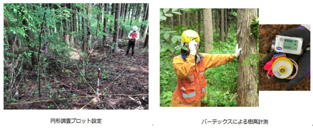
On the other hand, conventional forestry surveys have had issues in terms of efficiency and cost. The conventional survey methods are the "tree-by-tree survey," in which the diameter and height of each tree is measured one by one, and the "plot survey," in which the diameter and height of each tree is measured for each plot, both of which require a lot of manpower and time. However, both of these methods require a lot of manpower and time. The use of laser measurement equipment or drones requires an initial investment of several hundred thousand to several million yen, which is a large cost burden. It has been difficult for conventional methods to meet the need for an easy, low-cost overview.
*Reference 1:JAPAN SDG Action Platform", Ministry of Foreign Affairs of Japan(Viewed September 22, 2025)
*Refer 2:Ministry of Economy, Trade and Industry, "Green Growth Strategy Accompanying Carbon Neutrality in 2050"(Viewed September 22, 2025)
*Reference 3:Forestry Agency, "Outline of Forest Development and Preservation Projects, FY2024-FY2010," p. 3.,(viewed September 22, 2025)
To solve these problems, the Japan Forest Technology Association developed the "Simple Forest Interior Measurement Tool" (*4), which uses all-sky photographs.
All that is needed is an all-sky camera priced around 100,000 yen, which can be purchased at electronics retailers, and a standard PC. Only photography is required on site, and there is no need to remove shrubs or underbrush. Analysis can be done with free software, which requires no installation or specialized knowledge. Moreover, if the forest is uniformly planted, the cross-sectional area of the forest can be estimated with an accuracy of ±10% of the actual value, providing data at a practical level.
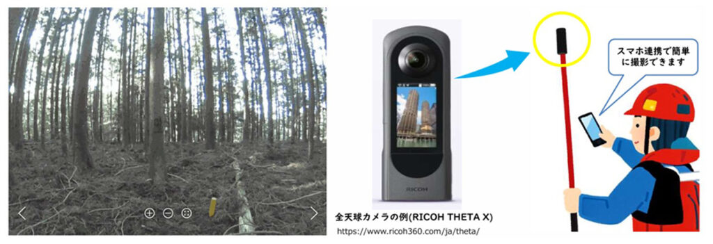
In 2013, Ricoh released the world's first all-sky camera, the THETA, and when we bought and used it, we realized that we could get forest information from all-sky photos."
This is the view of Mr. Masahiko Kanamori, Executive Director of the Japan Forest Technology Association, which developed the simple forest measurement tool. He says that when he compares field surveys and photographic measurements at government training programs, he is often surprised by the surprisingly high accuracy of the results.
I feel the great appeal of this technology is that we can get data that is as accurate as a tree-by-tree survey."
*Refer to 4:Forest Information Site Ro-Moriban(Viewed September 22, 2025)
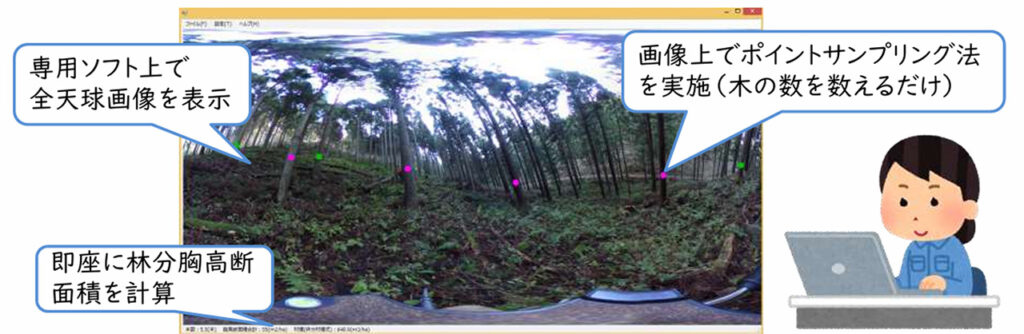
This method is a modern application of the "point sampling method" invented by Austrian forester Bitterlich some 80 years ago to estimate forest breast height cross sections* without setting up a plot. Traditionally, this method was studied using a tool called a sighting instrument, but the same principle can be implemented on a computer screen by using an all-sky photograph. Slope forest areas can also be analyzed as they are, without the need for tilt correction that was previously required.
The actual process is also very simple. Several all-sky photographs are taken in the forest, and the images are imported into a PC. Simply drag and drop the images into the dedicated software, click on the target trees with the mouse and count them, and the cross-sectional area of the entire forest is automatically calculated.
The results can be saved as a CSV file and can be used to calculate carbon credits. The software was developed as part of a government subsidized project and is available to anyone free of charge.
The accuracy was tested in 18 locations in artificial coniferous forests such as cedar and cypress, and the results were very stable with an average error of 0.7% (maximum +8.931 TP3T to minimum -9.881 TP3T) and no variation from the actual measurement values. It is particularly noteworthy that the accuracy did not drop even in forests with a lot of underbrush or in conditions where laser measurement is not very good.
The total cross-sectional area of all trees in a forest is called the forest area at breast height, and is used as an indicator of the amount of forest resources.
Japan Forest Technology Association will also provide user support. Various services can be provided to meet the needs of users, including free consultation via e-mail and online meetings, contracted field surveys, analysis of photographed images on behalf of users, report preparation, and support for carbon credit calculations.
Forests are the property of society as a whole. This tool can be used for a wide range of purposes, from forest monitoring by the government to management of company-owned forests and privately owned forests. We hope that this technology will help people take on the challenge of knowing their own forests in a more accessible way. (Mr. Kanamori)
Forest measurement using all-sky imagery is a new method that is "easy, inexpensive, and accurate enough. It is a great help to forest owners and companies, as it allows them to easily determine the amount of forest resources and CO2 absorption without the need for conventional expensive equipment. It is expected to be a powerful tool for forest management and the creation of a decarbonized society in the future. (Nozomu Kanemoto, Forestry Consultant, Leaf Rain Co.)
