Drawing the future of forestry with laser forest phase diagram
Updated by Asia Koso Corporation on May 20, 2025, 8:38 AM JST
Asia Air Survey Group
Since its establishment in 1954, the company has provided comprehensive technical services ranging from collection and analysis of spatial information using state-of-the-art aircraft and sensors to methods of utilization. Currently, through geospatial information consulting, the company is engaged in a wide range of land conservation, social infrastructure construction, and management businesses. 2022 will see the conclusion of a strategic sales partnership with AXELSPACE Corporation. In the same year, he was certified as a "DX Certified Business Operator" by the Ministry of Economy, Trade and Industry.Official Site
The vast forest resources that currently occupy about two-thirds of Japan's land area are difficult to accurately assess in terms of quantity and quality due to their size and diversity, and this is a major hindrance to their utilization and efficiency in the forestry industry. A long-established aerial surveying company, Asia Koso Corporation, is taking on the challenge of using advanced remote sensing technology to address these issues.
As the company name implies, Asia Koso flies extensively throughout Japan with its own aircraft, and in recent years has expanded from aerial photogrammetry to digital measurement as its mainstay.
We entered this field about 15 years ago in the 2008's. We wanted to contribute to making Japan's forests the way they should be by utilizing our accumulated geospatial information technology. We entered this field about 15 years ago in the 2008's. We wanted to contribute to making Japan's forests the way they should be by utilizing our accumulated geospatial information technology.
Mr. Mochihiro Ota, Director of the Forest Solution Technology Department, says so. What is the company's "ideal state"?
We want to realize a state in which forests exist in various locations in a state suitable for the functions they are expected to perform, such as timber production, environmental conservation, human interaction, and disaster prevention, and in which people can earn income from forest-related work, gain peace of mind, and live safely against natural disasters. To achieve this, it is necessary to develop basic information on the topography and individual trees, analyze and plan based on this information, and provide tools for use such as GIS (Geographic Information System), cloud computing and other platforms for information sharing, and tablets. The backbone of this process is the aerial survey. The backbone of this process is resource analysis based on aerial laser measurements."
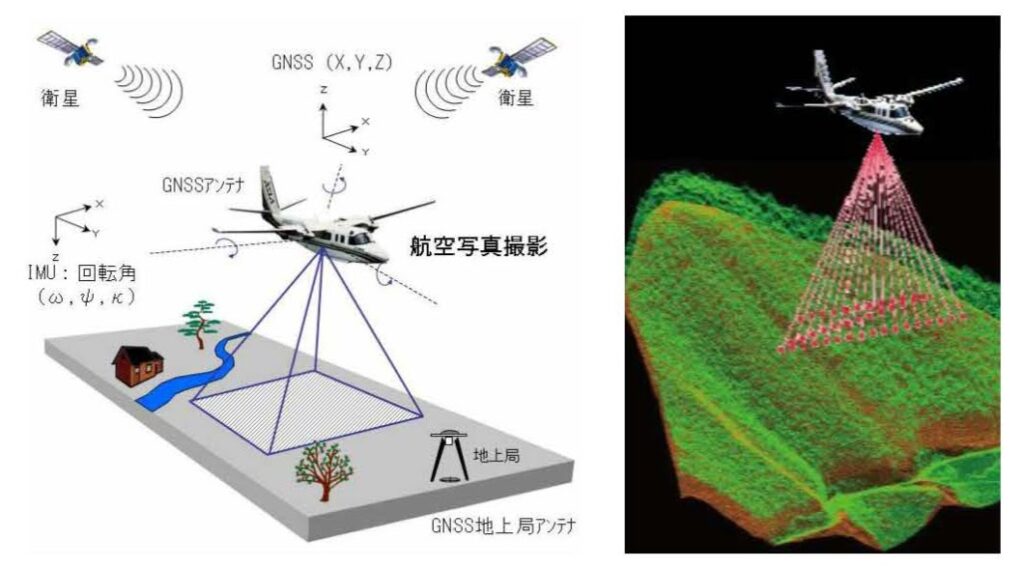
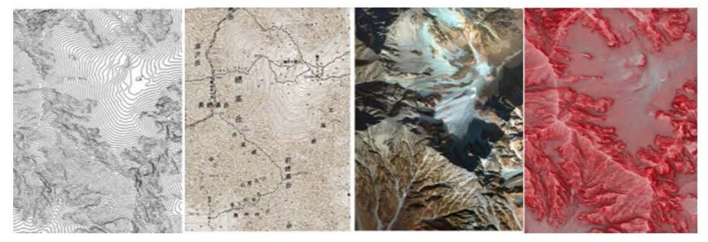
This technology measures the time and strength of laser pulses emitted from an aircraft until they are reflected back by buildings, trees, the ground, and other ground objects. Using this data, it is possible to create a three-dimensional map (patented "red three-dimensional map") based on the elevation and horizontal coordinates of a 50 cm square (depending on the density of laser pulses), as well as the number of standing trees and their location coordinates, the height of trees based on the difference in reflection time between the ground and tree canopy, and even tree species and timber volume. The number of standing trees and their location coordinates
The reflection of laser pulses differs depending on the surface of the tree and the texture of the tree shape; for example, it is stronger for cypress and weaker for cedar, and by measuring this, the tree species can be determined. Another advantage of our patented technology (jointly authored with TEPCO), "Tree Apex Extraction," is that it can extract the sharpest point of a tree's crown shape, allowing us to determine the height of each tree more accurately than with conventional methods.
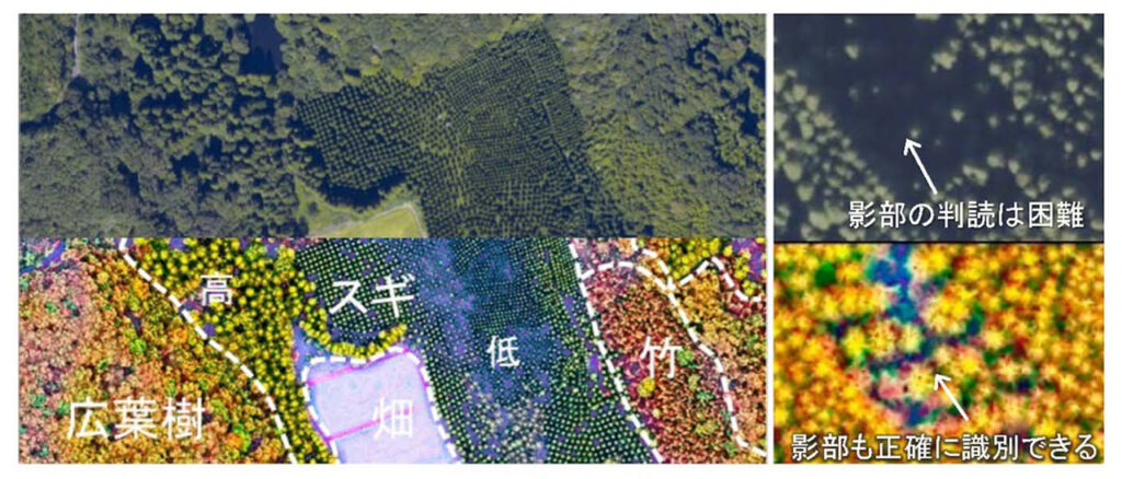
With the "laser forest map" created in this way, it is easy to distinguish between young forests and young forests based on tree height, and to identify forest phases, not to mention shadow areas, which have been difficult to distinguish from aerial photographs. Since the diameter at breast height can also be estimated based on the correlation with the spread of the tree canopy, it is now possible to accurately calculate the volume of timber volume of each individual tree and the total forest accumulation. Recently, AI based on sample data has been used to decipher the forest physiognomy, and the benefits to the forestry business are truly great.
By overlaying individual tree data on a digital map, resource information such as the number of trees, average tree height, and total timber volume can be seen at a glance, enabling appropriate proposals for operations such as clear cutting and thinning that are optimized for the period of use. In addition, log conversions are important for estimating sales from timber collection in the forestry industry, and the number and volume of logs by length and grade can be instantly estimated for each sub-group and lot number.
In actual operations, in addition to identifying the minimum distance of timber collection on a map, the software offers many advantages, such as easy trial and error in examining working paths and forest road planning, which used to require time, labor, and budget for on-site inspections. The Forestry Agency is promoting a "forest management system" for municipalities that links forest owners and forestry managers, and hopes are high that the system will be able to provide forest zoning and confirm the intentions of the parties involved.
In the forest management system, problems related to forest boundaries and ownership tend to be a major obstacle. Often there are cases where the boundaries are not known because of unclear official maps from decades ago or "oral tradition" of elderly or deceased owners. If you use a red three-dimensional map, you can confirm the boundary of the land and reach a consensus smoothly by looking at the "charcoal burn site" and "boulders" in addition to the ridge and valley. The red 3D map also facilitates the confirmation of the boundaries of the parcel and the formation of consensus.

Naturally, there are high expectations for the use of forest information in terms of absorption and fixation of greenhouse gases. To this end, Asian Kosoku has been promoting the use of laser survey data to identify the status of the forests in question on a yearly basis for the generation of J-credits. In addition to sending employees to Yusuhara Town, Kochi Prefecture, to support the acquisition of J-Credits, the company is also calculating the amount of CO2 absorption by forest age in Izumo City, Fukui Prefecture, and Ikeda Town.
In the area of resource analysis using aerial laser measurement, we were the first in Japan to analyze the entire area of Saga Prefecture in 2011, and we have now completed about 60% of the entire land area of the country. As we have made achievements in the forest management system, including the formulation of a forest vision for Ukiha City in Fukuoka Prefecture, what we would like to focus on most is the realization of a forestry DX as a cloud system that centrally manages all information, including forest resource data, timber supply and demand data, and ledger data for operators, owners, and local governments," he said.

Mr. Ota's vision is in line with the Platinum Forest Industry Initiative's vision of "smart forestry. To achieve this goal, the company is currently working to accumulate as many success stories as possible.

The book of the same title as this web media, "Forest Circular Economy" (edited by Hiroshi Komiyama) was published by Heibonsha on August 5, 2025. The book proposes a redesign of the economy, institutions, and local communities based on the three pillars of biomass chemistry, wooden cities, and forestry innovation in the cycle of "cutting, using, planting, and nurturing" forests. This practical book provides a point of contact between concepts and examples for those involved in policy making, social implementation, and the creation of businesses that make use of local resources.
View on Amazon
