
Photo by Kazuo Watanabe
Trees lining the water's edge adorn Tokyo's only waterside landscape—the dawn redwood grove that has become the symbol of Mizumoto Park.
Updated by Kazuo Watanabe on July 3, 2026, at 8:46 p.m. JST
Kazuo WATANABE
As a forest instructor, he spreads knowledge about trees and explains the natural environment, and teaches at NHK Culture Center, Mainichi Culture Center, Yomiuri Culture, NHK Gakuen, and others. He is the author of "Trees in Parks and Shrines," "15 Mysteries to Enjoy Roadside Trees," "Why Do Hydrangeas Collect Aluminum Poison in Their Leaves? Completed the graduate course at Tokyo University of Agriculture and Technology. Doctor of Agriculture.
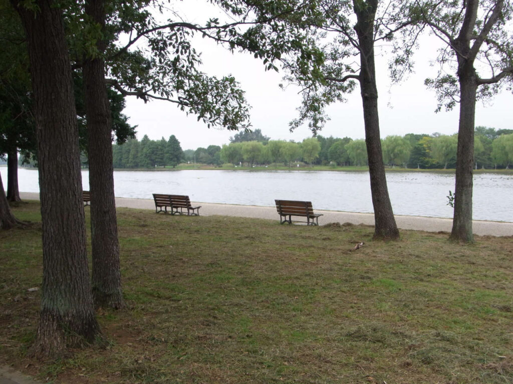
When it comes to “water towns,” places like Itako in Ibaraki Prefecture are well-known in the Kanto region, but there are also parks within Tokyo’s 23 wards where you can enjoy “water town” scenery. “Mizumoto Park,” located in Katsushika Ward, Tokyo, is known as the only park in the city where visitors can enjoy a “water town” landscape. Within the park lies a massive marsh called “Koai-dame,” whose water surface creates a spacious, open landscape (Photo 1, Photo 2).
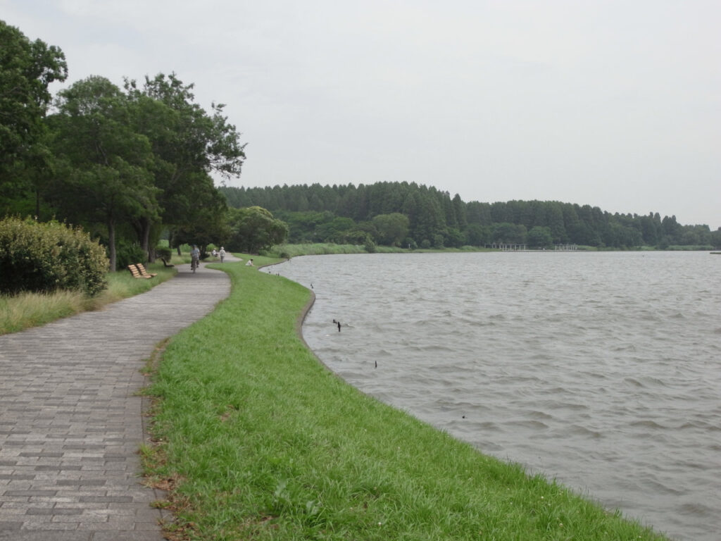
Kogai Reservoir is a large reservoir created during the Edo period by damming the Furutone River; in other words, it is a remnant of the Furutone River. As if to hint at its origins as a major river, it meanders gently, stretching 100 meters wide and 3.5 kilometers long. Walking along its banks fills one with a truly refreshing sense of clarity. The sight of green trees reflected in the expansive water surface soothes the soul. Although it is not far from the city center, this is indeed a “water town,” and even the trees thriving along the marsh’s edge are deeply intertwined with the waterside environment.
How did the waterside landscape of Mizumoto Park come to be? The plain where Mizumoto Park is located is a flat, low-lying area known as the Nakagawa Lowlands. The reason the terrain is so flat is that the land was formed by the accumulation of sediment carried by floodwaters.
Within Mizumoto Park, there are not only traces of the current course of the Kori River but also several remnants of the river’s former courses. Aerial photographs taken from an airplane reveal several traces of meandering river channels scattered across the Nakagawa Lowlands, suggesting that the river changed its course with each flood. When floods occurred and the river overflowed its banks, the sediment carried by the floodwaters accumulated on the plain. In other words, the area where Mizumoto Park is located is a “floodplain” formed over time by repeated river flooding, which caused the river to change its course and deposit sediment.
The flooding caused by Typhoon Kathleen serves as an example of such flooding. In September of Shōwa 22 (1947), shortly after the end of the war, Typhoon Kathleen brought heavy rainfall to the Kanto region and is known for causing severe flooding in Tokyo. On September 16, the embankment of the Tone River in Saitama Prefecture breached, and the floodwaters slowly flowed down through the Nakagawa lowlands. By the 18th, they had reached the “Sakura Embankment,” adjacent to what is now Mizumoto Park, where they were temporarily held back. However, in the early hours of the 19th, the Sakura Embankment finally breached, and the Nakagawa River levee also collapsed. As a result, areas such as Kanamachi and Shibamata in Katsushika Ward were submerged. This flooding inundated the entire Katsushika Ward, and it took a full 20 days for the water to recede. Furthermore, large amounts of sediment were left behind in the fields and villages. Records show that such floods had occurred several times during the Meiji and Edo periods, even before Typhoon Kathleen, illustrating that the landscape of this water-rich region is deeply intertwined with recurring floods.
In Showa 40 (1965), 18 years after the flooding caused by Typhoon Kathleen, the area around the Koai Reservoir—which had previously been covered in farmland—was developed into “Tokyo Metropolitan Mizumoto Park.” As the only park in Tokyo featuring a waterfront landscape, and one of the largest in the 23 wards, it became a place enjoyed by many people. The Sakura Embankment, which halted the floodwaters during Typhoon Kathleen, is now a row of cherry trees adjacent to the park and bustles with visitors during the spring cherry blossom season. Within the park, attractions such as an iris garden, a forest of 2,000 metasequoia trees, and an exotic poplar-lined avenue have been created and serve as highlights of the park. Kingfishers, which are waterbirds, are often spotted here, much to the delight of photographers. Additionally, the park is now equipped with disaster prevention facilities, such as a helipad and emergency restrooms, and serves as a disaster prevention park in the event of a disaster.
Mizumoto Park, a waterfront park, features many trees well-suited to waterside environments. These include metasequoia, larch, poplar, alder, enoki, and Japanese elm. Among these, the metasequoias form the most magnificent forest. Metasequoias are conifers native to China, distinguished by their straight trunks and strikingly beautiful conical crowns. Furthermore, as a deciduous tree, its leaves turn reddish-brown in the fall, and in the spring, young leaves sprout, bringing a bright splash of color. Approximately 2,000 Metasequoia trees have been planted along the banks of the Koai Pond, and this beautiful forest has become one of the symbols of Mizumoto Park (Photo 3). In Showa 43 (1968), to commemorate the 100th anniversary of the Meiji era, efforts were made to improve the park’s woodlands. The metasequoia grove was also planted as part of the Meiji Centennial Commemorative Project.
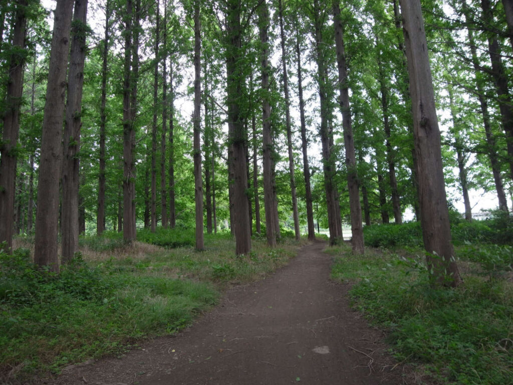
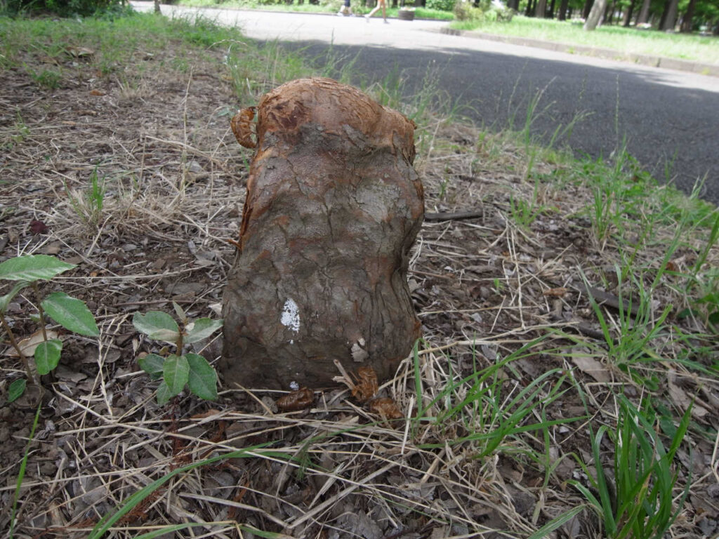
Metasequoia was once thought to have become extinct on Earth, but in 1946 it was discovered in China that the species was still alive, and it became a topic of conversation as a “living fossil.” In its native China, it is called “Shuisan” and is said to have grown along waterways. The larch (Larix), a conifer very similar to the metasequoia, is known in Japanese as “Numasugi” (marsh cedar) and is also capable of growing in marshy areas. It possesses the unique ability to raise its roots to breathe even when its base is submerged; within the park, you can see Chinese dawn redwoods with their roots raised like stakes (Photo 4).
Along the banks of the Koai Pond, you can see a stand of alder trees. Alder is a tree that is highly adapted to wetlands. It is resilient enough to survive even if its roots are submerged for a certain period of time, and it can form stands in wetlands—environments where other trees struggle to grow. However, it is difficult to find wild alder forests on the Japanese archipelago today. This is because wetlands themselves have diminished due to development.
As for natural vegetation, Enoki trees are commonly seen. Enoki trees are common along riverbanks and have adapted to the natural phenomenon of river flooding. They excel at sprouting and growing in areas where rivers have flooded and sediment has accumulated—in other words, in new, unclaimed land where other trees have not yet taken root. The Japanese elm (Akinire) shares similar characteristics and is particularly common along rivers in western Japan. It may have successfully adapted to take advantage of recurring floods.
The symbol of Mizumoto Park is, without a doubt, the expansive water surface of Koai Pond. At the same time, the trees lining the water’s edge—including metasequoias, Chinese firs, poplars, alders, Japanese elms, and enoki trees—are also elements of the natural landscape that tell the story of Mizumoto’s environment. (Forest Instructor Kazuo Watanabe)
Trees in parks and shrines"
Written by Kazuo Watanabe, published by Tsukiji Shokan
An oasis of greenery loved by people, this book introduces the history and episodes hidden in this oasis of greenery. Through the trees in parks and shrines, this book will rediscover how people have been involved with trees, the way trees live, and their charms.
<Table of Contents
Chapter 1: Sleepless Platanus
Chapter 2: War-Torn Azaleas and Dogwoods
Chapter 3: Enoki, the History of Suigo
Chapter 4: Sudajii fought the Great Fire of Edo
Chapter 5 Camphor Tree from Taiwan
Chapter 6: Why did Eiichi Shibusawa build the park?
Chapter 7: How Ginkgo Came to Be Worshipped
Chapter 8: 5,000 Years of History Hidden in the Cherry Hill
